Marvellous Mechanical Drafting with Autodesk AutoCAD Mechanical
Marvellous Mechanical Drafting with Autodesk AutoCAD Mechanical
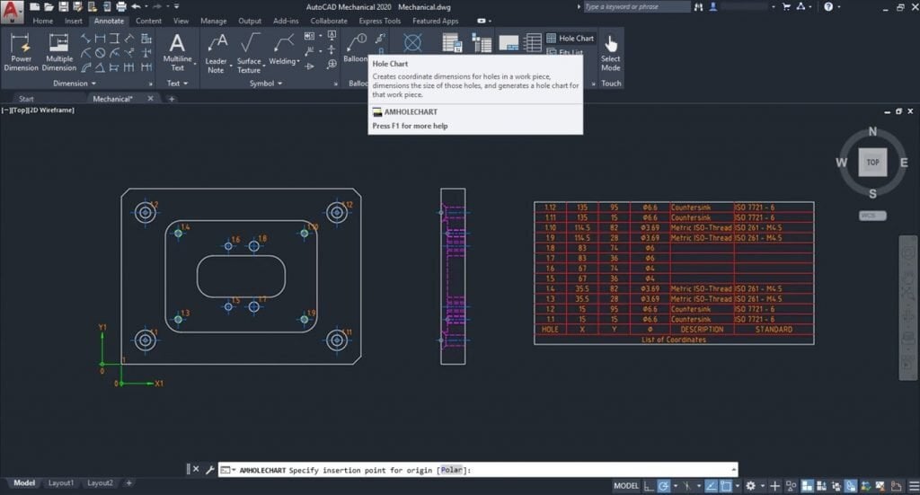
Did you know that the global CAD software market was valued at $9.3 billion in 2019 and is projected to grow at a rate of 6.6% annually, reaching $18.7 billion by 2030? This growth is driven by the increasing complexity of design requirements and the need for more efficient and accurate tools in industries like manufacturing and automotive.
In this environment, what if you could cut your design time nearly in half while simultaneously reducing errors and enhancing the quality of your work? This is not just a dream but a reality with Autodesk AutoCAD Mechanical, a specialised toolset within AutoCAD that is revolutionising the field of mechanical drafting.
AutoCAD Mechanical is not just another CAD software; it’s a comprehensive solution tailored specifically for mechanical engineering. It combines the robust capabilities of AutoCAD with libraries of standards-based parts and tools designed to automate common mechanical CAD tasks. This powerful combination allows engineers and designers to save countless hours on design and rework, freeing them to focus on innovation and problem-solving.
In this blog post, we’ll explore the marvels of mechanical drafting with AutoCAD Mechanical, delving into its features, benefits, and the impressive productivity gains it offers.
Productivity Gains with Autodesk AutoCAD Mechanical
A productivity study commissioned by Autodesk highlighted the significant time savings and efficiency improvements offered by the Mechanical toolset in AutoCAD. The study compared the time required to complete various design tasks using Autodesk AutoCAD Mechanical vs AutoCAD.
Here are some key findings from the study:
- Faster Design and Rework: The Mechanical toolset reduces the total time required for 2D CAD work by approximately 55%. This is achieved through automation and the availability of standardised parts and functions.
- Reduced Risk of Errors: Standardised functions and parts not only speed up the design process but significantly reduce the risk of errors. This leads to higher accuracy and consistency in designs.
- Enhanced Efficiency: Common design tasks, such as searching for project data, inserting standard and supplier parts, and structuring data, are all streamlined with the Mechanical toolset. This efficiency frees up valuable time for more critical aspects of design.
Advantages of Using Autodesk AutoCAD Mechanical
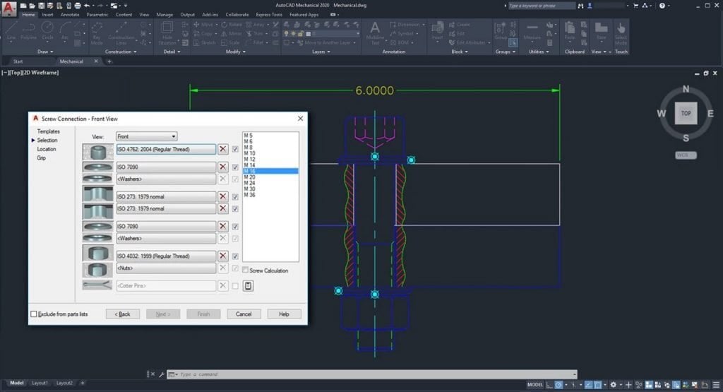
AutoCAD Mechanical offers numerous advantages that significantly enhance the efficiency and effectiveness of mechanical drafting. Here are some key benefits:
- Intelligent Layer Management: The Mechanical toolset in AutoCAD simplifies the task of managing layers by automatically placing items on the correct layer, colour, and linetype as you create your drawing. This system can be easily customised based on your company’s requirements, ensuring consistency and accuracy in your designs. Customisable layer types include text and hatching, centerlines and construction lines, hidden lines, symbols and notes, and title borders.
- Time Savings and Efficiency: AutoCAD Mechanical substantially reduces the time required to complete various tasks. For instance, preparing existing data, creating new concepts, and structuring data are significantly faster with the Mechanical toolset, resulting in up to 45% time savings. Similarly, tasks such as detailing and optimising new designs, calculating forces, and modifying parts are completed much quicker compared to basic AutoCAD, often saving up to 80% of the time.
- Enhanced Calculation Functions: The toolset offers robust calculation functions, allowing users to perform analysis on 2D geometry subject to static loads. This includes calculating stress and deformation in a plane or cross-section with individual forces and stretching loads. These capabilities are crucial for ensuring the structural integrity and performance of mechanical parts.
- Automated Updates and Synchronisation: The Mechanical toolset ensures that any change made to a component automatically updates all related components. This feature is particularly beneficial in complex assemblies where changes to one part must be reflected across the entire design. This automation reduces the likelihood of errors and ensures that all parts of the design remain consistent.
- Comprehensive Standard Parts Library: Autodesk AutoCAD Mechanical includes a vast library of over 100,000 pre-drawn standard features such as undercuts, keyways, and thread ends, and more than 8,000 pre-drawn holes including through holes, blind holes, counterbored holes, countersunk holes, and oblong holes. These features automatically clean up the insertion area in the drawing, eliminating the need for manual editing and significantly speeding up the design process.
- Efficient Production Drawing Creation: The toolset makes creating production drawings for parts and assemblies much more efficient. Automated and associative parts lists and bills of materials (BOMs) update automatically as the design changes. This ensures that all documentation is up-to-date and accurate, facilitating smoother transitions to manufacturing and reducing production delays.
- Power Commands: AutoCAD Mechanical’s Power Commands utilise object information to accelerate user operations such as editing and copying objects. This feature allows users to bypass traditional pull-down menus, toolbars, and tablet locations, using the objects themselves as command menus. This intuitive interface streamlines the design process and enhances productivity.
- Specialised Drafting Tools: The toolset includes over 30 options for rectangle, arc, and circle creation, nearly automatic centerline creation and updating, speciality lines for breakout views and section lines, and a full suite of construction lines for aligning drafting views. These specialised tools are designed specifically for mechanical drafting, providing more precise and efficient ways to create detailed and accurate drawings.
- Foreground/Background Management: AutoCAD Mechanical simplifies the management of foreground and background elements in a drawing. It automatically redraws geometry to show hidden or dashed lines of parts obstructed by other parts in a design. Hidden lines update automatically when changes occur, eliminating the need for manual redrawing due to design changes. This feature ensures that designs are always clear and accurate, reducing the time and effort required to update 2D designs.
These advantages make Autodesk AutoCAD Mechanical an indispensable tool for mechanical engineers and designers, enabling them to produce high-quality, precise, and efficient designs with less effort and in less time. Whether you’re working on simple components or complex assemblies, the Mechanical toolset offers the functionality and flexibility needed to meet the demands of modern mechanical design.
Embrace the Future of Mechanical Drafting with Autodesk AutoCAD Mechanical
Autodesk AutoCAD Mechanical is a powerful toolset that revolutionises mechanical drafting by enhancing productivity, reducing errors, and automating routine tasks. Whether you’re designing complex machinery, optimising existing designs, or calculating forces in a mechanism, AutoCAD Mechanical provides the tools and features you need to work more efficiently and accurately.
By incorporating AutoCAD Mechanical into your workflow, you can significantly cut down on design and rework time, allowing you to focus on innovation and quality. Embrace the marvels of mechanical drafting with AutoCAD Mechanical and take your engineering projects to new heights.
Contact Us
Contact us to find out how we can help your business. Fill out the form below, by live chat, phone or email.
P: 1800 490 514 | E: [email protected]


